Accra’s water bodies were killed and buried under a concrete jungle that now haunts residents

The devastating floods of Monday June 29, 2026 was long in coming. Within 24 hours, it was reported that about 12 people have died, seven missing and 7,761 households displaced. There are concerns that the death toll would rise as the flood waters recede and headcounts become clearer. The true full cost of the grim outcomes of the floods may never be known. But there are people who have lived long enough and know about Accra’s water courses.
In this two-part write-up, we delve into the history of Accra’s water bodies and how the authorities, traditional rulers, business people and residents recklessly destroyed them and left the city at the mercy of floods.
The floods after the rains on Monday is one of many in recent times. Won’t be the last, as the coming days would see more rains in the capital. Accra once had rivers, streams, lagoons and wetlands that soaked in the rain waters. But these water bodies have all been killed, exposing the city to deadly floods.
Accra was not only a city of asphalted roads, high rise buildings and beaches. That’s not what was in the beginning. Only few people alive today and familiar with Accra before the current invasion and disfigurement would remember that long before highways crisscrossed the capital, before neighbourhoods stretched from Weija to Adenta and Madina to Tema, Accra was a city embraced by and in the cool splashes of waters.
Its rivers snaked across valleys through plains, and its lagoons were populated with fish and migratory birds flapped their wings and nestled at the beds. There were also seasonal wetlands that soaked up floodwaters during the rains before releasing them gradually into the Gulf of Guinea. Streams flowing from the Akwapim Hills fed rivers that sustained farming communities and supplied freshwater to villages that would later become suburbs of the overcrowded capital.
Today, as we speak, much of that landscape has disappeared.
Many of the streams that once cooled the heels of trekking farmers and quenched the thirst of many weary travellers have become concrete drains. Almost all the wetlands have been filled with garbage, sand and construction wastes and reclaimed for housing, roads and commercial developments; while lagoons that once provided for thriving fishermen and fishmongers have become repositories for untreated sewage, industrial effluent and plastic waste. Rivers that once served as ecological lifelines now carry storm water mixed with refuse through densely populated settlements before emptying into some of the most polluted coastal waters in West Africa.
This grotesque transformation did not happen overnight. It unfolded gradually over decades as Accra expanded faster than planning systems could accommodate. Population growth, weak enforcement of environmental regulations, corruption, sheer carelessness, uncontrolled urbanisation and inadequate waste management steadily and brutally overwhelmed natural drainage systems.
The result of all the unhinged behaviours is a city where flooding has become almost routine, water quality has deteriorated dramatically and ecosystems that once protected communities have themselves become casualties of the uncontrolled development.
This is the story of how Accra’s waters were lost.
Accra – a city born on water
The Greater Accra Region occupies a relatively flat coastal plain intersected by numerous rivers, streams, lagoons and wetlands that together form one interconnected hydrological system. These watercourses serve important purposes. Each time it rains, these water systems drain rain water from the inland hills and rolls them toward the Atlantic Ocean, while sustaining biodiversity, agriculture and human settlements.
As aptly captured in the Greater Accra Regional Spatial Development Framework – Baseline Assessment Report Volume 1, prepared in June 2017, hydrology is one of the defining natural features of the region. Rivers such as the Densu, Odaw and Volta systems, together with an extensive network of tributaries, wetlands and coastal lagoons, shape both the region’s ecology and its patterns of settlement. The framework also notes that these natural systems play a critical role in groundwater recharge, flood regulation and environmental sustainability.
But unlike many inland cities whose rivers remain largely visible, Accra’s water network has become partly hidden beneath roads, neighbourhoods and commercial districts.
The Odaw River begins as a relatively modest watercourse north of the city before gathering numerous tributaries, including the Onyasia, Nima, Dakobi and Ado streams. Together they drain much of metropolitan Accra before emptying into the Korle Lagoon and eventually the Gulf of Guinea.
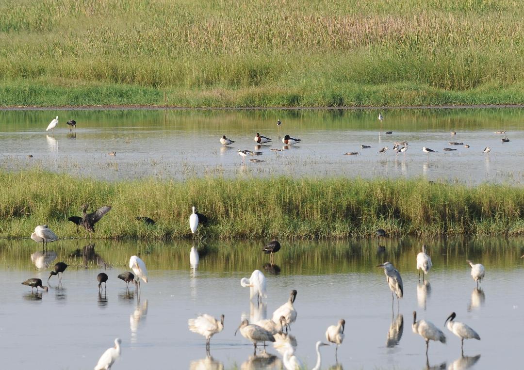
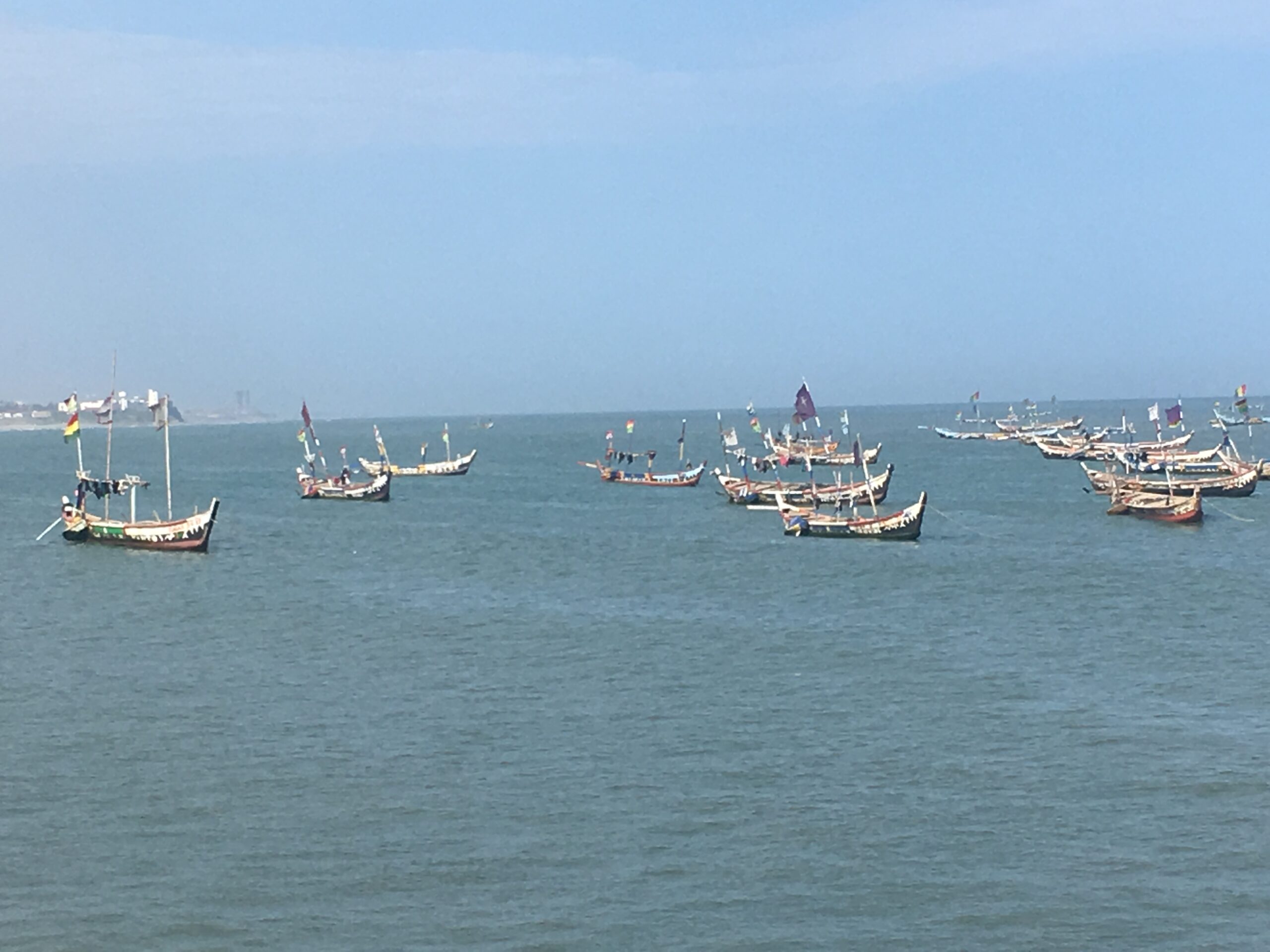
To the west lies the Densu Basin, one of southern Ghana’s most important rivers. The river feeds the Weija Reservoir, which supplies drinking water to millions of residents in the Greater Accra Metropolitan Area. Further east are the Sakumo, Kpeshie and Chemu lagoons, each supporting unique wetland ecosystems that once attracted migratory birds from Europe and Asia.
These water bodies were never isolated features. They formed one integrated ecological network.
During the rainy season, these wetlands stored excess runoff, reducing flood peaks downstream. The sedges, reeds and mangrove vegetation filtered sediments and pollutants before water reached lagoons and the sea. Different species of fish bred in the estuarine environments while migratory birds depended on the shallow wetlands during their seasonal journeys.
For centuries, these ecosystems quietly performed services that modern cities now spend billions trying to replicate through engineering.
Nature’s flood insurance
These wetlands were never given the attention that were given to rivers, yet they were Accra’s most valuable natural infrastructure, almost like the heartbeat of the capital, serving as insurance against floods.
The Framework doesn’t only identify numerous wetlands across the region, it also recognises them as environmentally sensitive landscapes that provided flood attenuation, habitat conservation and groundwater recharge. The Framework additionally documents increasing degradation resulting from urban development and changing land use.
Historically, floodwaters spread naturally across flood plains before slowly draining away, in a process that reduced pressure on rivers, and protected downstream communities.
Unlike many inland cities whose rivers remain largely visible, Accra’s water network has become partly hidden beneath roads, neighbourhoods and commercial districts.
But as urbanisation accelerated after independence, these open spaces increasingly came to be viewed as vacant land awaiting development rather than critical ecological infrastructure.
Housing estates expanded into floodplains. Commercial facilities occupied marshes. Road construction interrupted natural drainage. Sand winning altered riverbanks. Informal settlements appeared along streams and lagoons, and every hectare of reclaimed wetland meant less room for floodwater.
As every blocked channel forced water elsewhere, the cumulative effect was subtle, slow but sure, and unnoticed at first, but then it became dangerous – devastating.
The river that became a drain
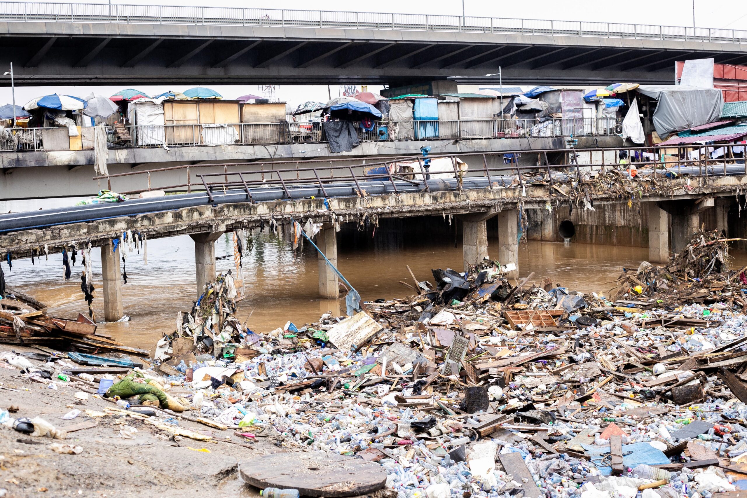
The Odaw River is the most visible waterbody in Accra. No watercourse illustrates Accra’s transformation more vividly than the Odaw. But today, many residents think of the Odaw primarily as a drain or big gutter. It is however, technically, far more than that.
The Odaw is the principal river draining metropolitan Accra, receiving runoff from numerous tributaries before discharging into the Korle Lagoon.
According to the Environmental Impact Assessment prepared for the Greater Accra Resilient and Integrated Development (GARID) Project, prepared for the dredging in the Odaw Basin in 2019 for the Ministry of Works and Housing, the Odaw Basin contains roughly 60 percent of the Greater Accra Region’s population, making it the country’s most densely populated river basin. Approximately 30 percent of people living within the basin occupy flood-prone informal settlements exposed to chronic flooding.
The report describes a basin transformed by intense urbanisation. Sections of the river have been lined with concrete to accelerate stormwater movement. Other sections remain natural but are heavily silted. Some stretches pass through industrial zones. Others flow alongside markets, residential neighbourhoods, transport terminals and informal settlements.
The river now receives runoff from virtually every aspect of urban life, but the stormwater carries plastics, discarded food, engine oil, heavy metals, sediments and untreated waste into the channel. Along parts of its course, illegal dumping further reduces flow capacity.
By the time the river reaches the Korle Lagoon, it bears little resemblance to the water course that once flowed through wetlands toward the sea.
The Korle Lagoon: from ecological treasure to environmental catastrophe
Where the Odaw ends, the Korle Lagoon begins. Few places symbolise Accra’s environmental decline so vividly and more powerfully.
Historical accounts describe the lagoon as a productive estuary supporting fishing communities, mangrove ecosystems and abundant birdlife. Today, it is more frequently associated with pollution, flooding and waste.
The GARID report found extensive sediment accumulation, poor water quality and widespread contamination throughout the lower Odaw and Korle Lagoon system, conditions that have significantly reduced hydraulic capacity while degrading aquatic ecosystems. The assessment identified the need for dredging nearly 10 kilometres of the river system to restore flow and reduce flood risk.
Several scientific studies have consistently documented elevated concentrations of pollutants in both water and sediments. Heavy metals, organic contaminants, nutrient loading and low dissolved oxygen levels have combined to create conditions hostile to many aquatic species, leading to dramatic decline in fish populations.
The mangrove vegetation has largely disappeared, and for many Accra residents, the Korle Lagoon is no longer perceived as a lagoon at all. It has become a symbol of neglect, and one must hold the nose while passing by it.
Its condition reflects processes occurring throughout the city’s wider watershed. The lagoon is not creating pollution. It is collecting it. Everything discarded upstream eventually ends up there.
The invisible cost of growth
The irony is difficult to ignore. Accra’s rapid expansion has brought undeniable economic opportunities. The city has become Ghana’s commercial, financial and administrative centre. Population growth has fuelled investment, infrastructure and commerce. But that same growth has steadily devoured the natural systems that once made urban life more resilient.
According to the Framework, integrated planning has struggled to keep pace with development, resulting in fragmented land use, encroachment into environmentally sensitive areas and increasing pressure on natural infrastructure.
Instead of allowing rivers room to flow, development squeezed them into narrower threads. Instead of preserving wetlands, the city suffocated them. Instead of treating rivers as ecological assets, they gradually became viewed as convenient drainage channels and dumping sites, and without any question, it is clear that the consequences now appear every rainy season. Floodwaters rise faster. Drainage systems become overwhelmed, and communities downstream pay the price. The recent rainy season is revealing new trends in flooding patterns, with communities that never got flooded before, now being overwhelmed by floods.
How a city outgrew its rivers
If Accra’s rivers could tell their own story, they would not speak of a single catastrophe.
There was no defining moment when the Odaw became polluted, when the Korle Lagoon ceased to sustain fishermen, or when wetlands suddenly stopped absorbing floodwaters. Rather, their decline came through thousands of small decisions and actions repeated over decades—houses built a little closer to riverbanks, refuse dumped into drains because collection failed or was unavailable, wetlands reclaimed one plot at a time, and industries discharging untreated effluent into streams. Individually, each decision appeared manageable, but collectively, they deformed an entire watershed.
Urbanisation without room for water
Accra’s population has grown at a pace few planners anticipated. From a modest colonial town, it has expanded into a sprawling metropolitan area stretching across multiple municipal jurisdictions. The Accra Metropolis is hosting a population estimated around four to five million people. Every decade brought new residential estates, industrial enclaves, shopping centres and transport corridors.
Urban growth, however, rarely respected natural drainage systems. Valleys that once carried seasonal streams became attractive sites for affordable housing or private real estate. Marshlands were viewed as vacant land awaiting development. Riverbanks that should have remained protected buffers gradually got covered with homes, workshops, markets and commercial structures, and the consequences extended beyond the immediate loss of wetlands. The concrete fundamentally altered the city’s hydrology.
Rain that once infiltrated soil now strikes rooftops, asphalt, cemented and paved compounds before rushing almost immediately into drains and rivers. The volume of stormwater entering the Odaw Basin during heavy rainfall has therefore increased dramatically, even when annual rainfall itself has changed just a little.
The Framework further warns that uncontrolled urban expansion has fragmented ecological systems and increased development within environmentally sensitive areas, weakening the region’s natural ability to regulate floods and protect water resources.
Nature’s drainage system was designed to slow water down. Urbanisation has done the opposite.
The disappearance of wetlands
Few environmental losses in Accra have been as significant, or as poorly appreciated – as the destruction of wetlands.
To developers, wetlands often appear as waterlogged land waiting to be reclaimed. Ecologists see something very different.
Wetlands function as natural reservoirs, temporarily storing floodwaters during storms before gradually releasing them into rivers. Their vegetation filters sediments, nutrients and pollutants while providing habitat for fish, amphibians and birds.
Accra once possessed an extensive network of such ecosystems. The Sakumo wetlands east of the city remain internationally recognised for their ecological importance, particularly as habitat for migratory birds. Yet even protected wetlands have come under increasing pressure from urban encroachment, illegal dumping and changing land use.
Elsewhere, many smaller wetlands have disappeared almost entirely beneath residential and commercial development. Their loss has consequences that extend well beyond biodiversity. Every wetland reclaimed for construction removes storage capacity from the city’s drainage system. Water that once spread harmlessly across marshes now surges directly into rivers. Flood peaks become higher, and the floods arrive faster.
Rivers that now carry the city
Rivers naturally transport water, sediment and organic material. In modern Accra, they transport much more.
The GARID Project paints a vivid picture of land uses along the Odaw River. Sampling locations were deliberately selected to capture the influence of dense settlements, markets, cattle rearing, automobile workshops and commercial activities distributed across the basin. Water and sediment analyses examined heavy metals, pesticides, organic pollutants and aquatic organisms to establish baseline environmental conditions. The picture that emerged was unsurprising yet deeply troubling.
The Odaw has effectively become a conveyor belt for urban waste. Every rainfall washes litter from roads, oil leaks from vehicles accumulate on pavements before entering drains; while construction sites contribute sediment, and markets generate organic waste.
Households without adequate sanitation infrastructure discharge wastewater into nearby drains, while industrial activities add their own pollutants. The river no longer reflects the quality of its own water, it instead reflects the condition of the city it drains.
Pollution below the surface
The most visible pollution floating along the Odaw or Korle Lagoon is only part of the story. Scientists have become increasingly concerned about contaminants hidden beneath the water.
The GARID assessment included laboratory analyses of water and sediments for heavy metals such as arsenic, cadmium and lead, together with pesticides, polychlorinated biphenyls (PCBs) and aquatic macroinvertebrates—organisms widely used as indicators of ecological health.
These investigations complement findings from peer-reviewed studies that have repeatedly documented elevated concentrations of heavy metals and other pollutants in parts of Accra’s aquatic environment. Such contaminants do not simply disappear. Many accumulate within bottom sediments. Others enter aquatic food chains. Some persist for decades.
Unlike floating plastic bottles that can be removed during cleanup exercises, chemical pollutants often remain embedded within riverbeds and lagoon sediments long after the original discharge has ceased. This creates a legacy of contamination that makes restoration considerably more difficult, because while cleaning the surface is relatively easy, cleaning the ecosystem is far more challenging.
The shrinking Densu

While the Odaw dominates discussions about flooding, the Densu Basin tells another story—the growing competition between urban expansion and water security.
The Densu River remains one of southern Ghana’s most important watercourses. Beginning from the Atewa landscape before flowing southward through several regions, it ultimately feeds the Weija Reservoir, which supplies treated drinking water to much of Accra and surrounding communities.
The Water Resources Commission has long recognised the basin as one of Ghana’s most economically significant river systems, supporting domestic water supply, agriculture, fisheries and industry. Yet it too faces mounting pressures.
Rapid urbanisation within the basin has increased pollution from settlements and agriculture while degrading riparian vegetation that once protected water quality.
While the Odaw dominates discussions about flooding, the Densu Basin tells another story—the growing competition between urban expansion and water security.
As illegal sand winning has destabilised riverbanks; deforestation has accelerated erosion. Changing land use has increased sediment entering the reservoir. But the challenge facing the Densu differs from that of the Odaw.
One is primarily an urban river overwhelmed by metropolitan growth. The other remains a strategic water supply system increasingly threatened by activities occurring throughout its catchment area. But both illustrate the same broader problem. Development has consistently outpaced watershed management.
Accra is disconnected from its rivers
One of the paradoxes of modern Accra is that many residents encounter its rivers every day without truly seeing them. Drivers cross the Odaw at Circle, Graphic Road and Kaneshie. Commuters cross bridges over the Onyasia. Residents live beside drainage channels that were once natural streams. They see them as places to be crossed and garbage to be dumped in, rather than appreciated.
That shift in perception has profound implications. Societies rarely protect what they no longer recognise as valuable. When rivers cease to be rivers in the public imagination, they become easier to pollute, easier to encroach upon and easier to neglect. Accra’s environmental challenge is therefore not only technical. It is cultural.
Recovering the city’s waters will require restoring not only ecosystems but also the public understanding that these rivers, lagoons and wetlands remain living systems whose health ultimately determines the resilience of the city itself.
The cost of neglect
On the evening of June 3, 2015, Accra experienced one of the darkest days in its history. Hours of torrential rain overwhelmed the city’s drainage system. Rivers burst their banks, roads became torrents and entire neighbourhoods disappeared beneath muddy floodwaters. As thousands scrambled for safety, fuel leaking from a nearby filling station ignited, triggering an explosion that claimed more than 150 lives at the GOIL station at the Kwame Nkrumah Circle.
The tragedy shocked the nation. But never awakened its conscience. Neither did it transform its knowledge base. In its aftermath, attention turned once again to blocked drains, indiscriminate dumping of refuse and poor urban planning.
Excavators arrived. Drains were desilted. Some structures were demolished. Choruses like “never again” were sang. Committees were set up. Reports were written and promises were made. Then, as the floodwaters receded, so too did the urgency.
More than a decade later, flooding remains one of Accra’s most persistent urban challenges—not because engineers do not understand the problem, but because the problem is far larger than blocked drains, and there is very little political will and interest to do anything worthwhile to address it.
That shift in perception has profound implications. Societies rarely protect what they no longer recognise as valuable. When rivers cease to be rivers in the public imagination, they become easier to pollute, easier to encroach upon and easier to neglect.
When rivers lose their capacity
Every river has a limit. As cities expand, rivers can continue performing their natural functions only if they retain enough space to carry water and if their channels remain unobstructed. The Odaw no longer enjoys either condition.
The GARID Project report describes extensive sediment accumulation throughout the river system, particularly in sections between Caprice, Abossey Okai, Old Fadama and the Korle Lagoon. The assessment concluded that nearly ten kilometres of the river channel required dredging to restore hydraulic capacity and reduce flooding. Sediment alone, however, is only part of the challenge.
Years of indiscriminate dumping have introduced enormous quantities of plastic waste, discarded furniture, car tyres, construction debris and household refuse into drains and streams. During heavy rains these materials move downstream until they become trapped beneath bridges, culverts and narrow sections of river channels. The effect resembles placing a cork inside a bottle.
Water continues arriving upstream but cannot escape quickly enough downstream. The river rises. Floodwaters spill over the banks and communities get flooded.
Engineers can remove the blockage, but unless the behaviour that created it changes, another blockage soon forms.
Flooding is becoming an urban condition
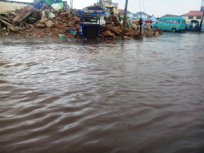
Floods are natural events, but urban disasters are not. Accra has always experienced seasonal rainfall, but flooding has become increasingly destructive because the city’s physical landscape has extensively changed.
The Greater Accra Metropolitan Area (GAMA) Sanitation and Water Project Environmental and Social Management Plan, prepared in 2017 and funded by World Bank observed that stormwater now poses severe risks to environmental sanitation, economic activity and public safety across several metropolitan districts, necessitating emergency drainage interventions to restore flood conveyance. Large areas that once absorbed rainfall have disappeared beneath impermeable surfaces. The rivers themselves have become narrower and shallower because of encroachment and sedimentation.
As more water arrives, less space exists to carry it, making flooding inevitable while climate change compounds the problem.
Scientists increasingly project that West Africa will experience more intense rainfall events, meaning larger volumes of water may fall within shorter periods. For a city whose natural drainage system has already been severely compromised, such changes present significant risks.
The silent disappearance of biodiversity
Floods capture headlines, because of the devastation they bring, but the loss of biodiversity rarely does, because it is subtle, and not easily noticeable.
Scientific investigations carried out under the GARID project included surveys of aquatic macroinvertebrates—small organisms whose presence or absence provides an important measure of river health. Together with chemical analyses of water and sediments, the studies sought to establish the ecological condition of the Odaw Basin before restoration works commenced.
Across the wider scientific literature, researchers have documented declining ecological quality in several of Accra’s aquatic systems, linking it to pollution, habitat destruction and altered hydrology.
Some species disappear because oxygen concentrations become too low. Others cannot tolerate heavy metals or excessive nutrient loading. Still others simply lose their habitat as wetlands vanish.
Unlike buildings destroyed by floods, ecological losses often occur quietly. Many residents may never realise what has disappeared because they never experienced the rivers as they once were.
Pollution that reaches the dinner table
The deterioration of Accra’s water bodies extends beyond environmental concerns. The decline affects the food chain.
It is a public health issue. Untreated wastewater entering rivers carries pathogens capable of contaminating downstream environments. Heavy metals accumulating within sediments may enter aquatic food chains.
Nutrient-rich runoff promotes excessive growth of algae and bacteria, reducing dissolved oxygen while creating conditions favourable for disease-causing organisms.
Communities that rely on contaminated waters for fishing, irrigation or other livelihoods face risks that are often difficult to detect immediately, but the danger is cumulative.
Pollution entering a stream today may remain within sediments for years. Heavy metals absorbed by aquatic organisms may gradually move through the food chain.
Restoring ecological health therefore requires addressing pollution at its source rather than simply cleaning rivers after contamination has already occurred.
What this requires therefore, is the political will, efforts at cultural revolution and a commitment to effect change by all means necessary.
By Emmanuel K Dogbevi